

Standing at 8,163 meters in the Mansiri Himal of Nepal, Mt. Manaslu has long been a mountain of fascination for climbers worldwide. Named after the Sanskrit word Manasa, meaning “intellect” or “soul,” the peak has seen a dramatic evolution in exploration over the past seven decades.
Japanese Interest in Early Exploration
The first recorded reconnaissance of Mt. Manaslu was carried out in 1950 AD by a Japanese expedition team. Over the following years, Japan developed a deep connection to the peak, becoming the driving force behind multiple early attempts to reach its summit.
Historic First Ascent in 1956 AD
Mt. Manaslu was successfully climbed for the first time on May 9, 1956 AD, by Toshio Imanishi of Japan and Gyalzen Norbu Sherpa of Nepal. The ascent, completed via the Northeast Face ridge during a Japanese Himalayan Expedition, made Manaslu the fourth 8,000-meter peak to be climbed, following Annapurna, Everest, and Nanga Parbat.
Historical Local Tensions, Early Challenges and the Current Commercial benefits
Before the landmark ascent, Japanese expeditions in 1953 & 1954 AD faced significant resistance from villagers in Sama Gaun, who accused earlier teams of triggering an avalanche that killed local livestock. After negotiations and compensation efforts, access to the mountain was restored.
The current commercial benefits of a Manaslu expedition lie in its unique combination of accessibility, affordability, and authentic Himalayan experience. Compared to other 8,000‑meter peaks, Manaslu offers a lower-cost entry into high-altitude mountaineering, with well-established trekking and climbing infrastructure that supports safer and more manageable ascents. Climbers and trekkers benefit from quieter, less crowded routes, gradual acclimatization opportunities, and breathtaking natural and cultural experiences within the Manaslu Conservation Area. Additionally, the growing popularity of expeditions provides significant economic support to local communities through jobs for guides, porters, and lodge operators, while promoting sustainable tourism and conservation efforts in the region.
Tragedy and Milestones in Subsequent Expeditions
The mountain’s climbing history also includes moments of tragedy. In 1972 AD, an avalanche struck a Korean expedition, killing 15 climbers-one of the deadliest accidents in Manaslu’s expedition history.
Two years later, in 1974 AD, Mt. Manaslu witnessed a groundbreaking achievement as an all-women Japanese expedition successfully reached the summit, marking a milestone for women in high-altitude mountaineering.
Rise of Modern Commercial Expeditions
From the 1990s onward, Manaslu has gained popularity as one of the more approachable 8,000-meter peaks, attracting climbers preparing for Mt. Everest expedition. Factors driving this surge include comparatively moderate technical difficulty, lower costs, and favorable acclimatization profiles. However, the mountain remains highly avalanche-prone, demanding careful planning and expert support.
Recent Trends and Safety Concerns
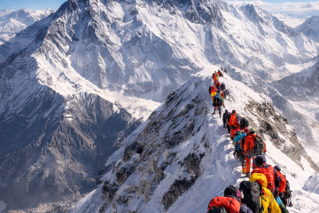
Since 2010 AD, expedition permits for Manaslu have risen sharply, with most climbers now following the standard Northeast route. Modern commercial teams rely heavily on highly skilled Nepalese local mountain guides & climbers for rope fixing coordinate by Department of tourism and Expedition Operators Association (EOA Nepal). Logistical support operating by the various of local agencies.
Despite improved organization, avalanches continue to pose the greatest risk, with several fatal incidents recorded in the 2010s and 2020s.
Southwest Face: Russian climbers Newly Established Route
Russian climber Andrei Vasiliev has dedicated years to demonstrating that 8,000-meter peaks still hold opportunities for new routes. This year, on Manaslu’s Southwest Face, he and his team executed a groundbreaking alpine-style ascent-completing the climb in a single push on-sight across previously unexplored terrain, both ascending and descending. Vasiliev, alongside teammates Sergey Kondrashkin, Vitaly Shipilov, Kirill Eizeman, and Natalia Belyankina, received widespread acclaim from the mountaineering community, including the Russian edition of the Piolet d’Or, awarded to them last weekend. The team shared insights and experiences from the expedition in an interview with Roofline Journal
Route Selection of the expedition
The team considered three potential climbing routes, contingent on prevailing conditions. However, adhering to a strict alpine style, they were able to access the chosen route only during their summit attempt. “We attempted to utilize a drone for reconnaissance, but our limited experience prevented us from obtaining meaningful data,” they noted. The drone malfunctioned and fell before reaching the icefall.
The team’s initial objective was to ascend a direct line through the center of the Southwest Face. The right section of the wall, which led to a steep rock tower, would have required an excessive amount of time. “All other viable lines predominantly comprised snow and ice sections, making accurate assessment of snow conditions critical.” The team reviewed data from The Himalayan Database, observing that numerous prior attempts occurred in September, with all reports indicating adverse weather conditions.
According to Vasiliev, “This year, the substantial monsoon-end snowfall occurred between September 30 and October 7 and was significantly lower than in previous years. We left Base Camp five days after the last precipitation, aiming to minimize snow on the face, and ultimately encountered nearly ideal climbing conditions.” The southwest slopes, the icefall, and the flat sections of the Thulagi Glacier continue to be highly susceptible to avalanches. “We closely monitored weather forecasts throughout the expedition and were fortunate that snowfall was virtually absent during our entire time on the mountain.”
The team’s chosen line is located approximately 1,000 meters to the right of the Tyrolean route first established by Reinhold Messner in 1972 AD. Separated by a prominent rocky section, the new Russian line ascends entirely uncharted terrain, representing a pioneering route on the Southwest Face.
Expedition daily Log
“According to Vasiliev, the route did not present any single, clearly defined crux. “However, the overall climb was highly demanding. One of the primary challenges was securing our upward progress. Aside from a few isolated sections, there was virtually no reliable ice on the face, leaving us dependent almost entirely on Deadman snow anchors for protection.”
From a technical standpoint, the most challenging segment was a mixed section between 7,500 and 7,700 meters, characterized by short rock steps combined with steep snow and firn slopes.
October 12: The team departed Base Camp carrying exceptionally heavy loads, each pack weighing between 32 and 35 kilograms.
October 13: After two hours of travel, the team arrived at the base of the icefall and assessed the complex serac formations to determine the safest route. The only viable line ascended the left flank, traversed through the central section, and continued up the upper headwall via a rock ridge. Although previous expeditions had employed fixed ropes on these rocky sections or climbed via the right side of the icefall, such options were incompatible with the team’s strict alpine-style approach.
October 14: The team began climbing at midnight, crossed the icefall to an altitude of 5,300 meters, and established a camp beneath the final serac.
October 15: The team traversed the relatively level plateau of the Thulagi Glacier while simultaneously evaluating the Southwest Face and discussing potential ascent lines.
October 16: A final decision regarding the route was made. Shortly thereafter, the first camp on the Southwest Face was established at 6,300 meters.
October 17: Climbing commenced on the Southwest Face, progressing up 30–55° snow slopes, primarily using simultaneous climbing techniques. The team bivouacked at 6,900 meters, just below a serac zone.
October 18: In the early morning, the team crossed the hazardous serac area. By 10:00 a.m., they reached a bergschrund that necessitated a camp, as the long, steep slope ahead offered no feasible bivouac sites.
October 19: The team continued upward, retrieving the rope as they climbed, and advanced onto a 60° snow slope. Protection was extremely limited; despite carrying extensive snow and ice gear, none of the equipment proved fully reliable in the prevailing conditions, significantly slowing progress.
October 20: Climbing resumed at 11:30 a.m. due to fatigue and challenging conditions. Only four pitches were completed that day.
October 21: The team tackled the most technically demanding section of the route—a mixed terrain band—and reached the high plateau at 7,730 meters. At this elevation, their line converged with both the classic and Tyrolean routes. (Note: both routes merge on a high plateau at approximately 7,400 meters before narrowing into a ridge that leads to the summit.)
October 22: Although the team expected a straightforward approach to the summit after completing the Southwest Face, strong winds made the final ascent difficult. They remained partially sheltered until the summit ridge, but conditions deteriorated sharply above it. The climbers reached the summit individually at 3:53 p.m., then descended to their bivouac between 6:30 and 7:00 p.m.
October 23: Descent began late, around 4:00 p.m. The team reached the lower section of the plateau (approximately 7,350 meters). Due to low visibility, they were unable to locate the Tyrolean route, though they believed it to be nearby.
October 24: The team located and began descending the Tyrolean route. They rappelled five pitches and fixed a rope for an additional 15 pitches. Four climbers descended on the fixed rope, while the final member removed the ropes and downclimbed. They bivouacked at the pass between the Thulagi Glacier and Manaslu, at approximately 6,500 meters.
October 25: The descent continued across the flat glacier down to 5,800 meters, where sections of their ascent track were still visible. By this point, food supplies were nearly exhausted.
October 26: The team crossed the upper icefall-requiring one rappel through the rock section. Numerous new crevasses had opened, though all remained passable. They waited until sunset to traverse a hazardous slope beneath a large couloir, then continued down to the base of the icefall. At 8:00 p.m., they reached the site previously used as their Advanced Base Camp.
October 27: After consuming their final handful of raisins in the morning, the team proceeded to Base Camp, arriving at approximately 5:00 p.m. Exhausted but elated, they prepared dinner and celebrated the successful completion of their expedition.
Notes on the descent
During the ascent, brief messages shared by the team suggested they had encountered difficulties during their descent due to a severe whiteout. However, according to Vasiliev Instagram that the situation was manageable. After the first day-when visibility was extremely poor-they were fortunate to experience a clear day, which allowed them to locate the correct descent line. If the poor visibility had persisted and we had been unable to locate the Tyrolean route, our contingency plan was to descend via the normal route on the opposite side of the mountain. What was absolutely not an option was descending the same line we had climbed. That route is significantly longer, gains an additional 600 vertical meters on the face, and traverses a hazardous section with extensive serac exposure.